Browsing Tag

Transportation

Brooklyn Heights

Yassky Zapskys Cabsky Appsky

August 10, 2012

Not so fast there. A new smartphone app hailed as a tech-savvy way to find a taxi could be a major boon for illegal gypsy cabs.

The ZabKab app, released Wednesday, allows anyone with an iPhone to register free as a driver—even if they’re not licensed by the Taxi and Limousine Commission, according to a story in the New York Daily News.

Livery and gypsy-cab drivers who aren’t legally allowed to pick up street hails could easily apply the same business savvy, which creates “a dangerous situation,” says Ira Goldstein, spokesman for a trade association of drivers & buses that cater to corporate clients.

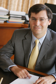
Brooklyn Heights resident and TLC Chairman David Yassky agrees that ZabKab is problematic: “I have definite concerns about the potential for people to be misled by the app, and for it to encourage illegal hustlers,” he says. The TLC has scheduled a meeting with creator Flatiron Apps to discuss its concerns. Continue Reading…


Source: Brooklyn Heights Blog
http://brooklynheightsblog.com/archives/45397

From the Web

Events

Car On Congress Walks Itself Across The Street?

August 10, 2012

A Cobble Hill Blog tipster who has lived in the neighborhood for a decade sent us the following mysterious quandary, which we shall file under the WTF category: “On Sunday we parked our car on Congress Street between Clinton and Henry on the north side, in a spot that would expire Thursday morning. When I dutifully went to move it last night, it was now on the south side of the street. The north side was covered in fresh tar and marked with saw horses, so clearly it was moved for road/utility work.”

She adds, “I am grateful the city did not tow the car (when we left it there Sunday we saw no warnings), but the car was in reverse with the emergency brake still on and locked, just as we left it. How in the world did they physically move it, and are there any regulations about this?”

Any ideas, out there?


Source: Cobble Hill Blog
http://cobblehillblog.com/archives/7725

From the Web

Brooklyn Heights

Council Members Ponder Widening Brooklyn Bridge Walkways

August 8, 2012

Three City Council members representing both Brooklyn and Manhattan believe the Brooklyn Bridge needs to fatten up. Citing tight quarters along the pedestrian and bicycle paths, the members proposed Tuesday to widen the upper-level platform for tourists and commuters.

The New York Times reports that Brooklyn Councilman Stephen Levin suggested that “the engineering and ideas community” could be enlisted to widen the artery by as much as three times its current span, perhaps through a competition organized by local design groups.

Likewise, Councilman Brad Lander of Brooklyn, believes that “just looking at how the path goes around the buttresses gives you a sense that a wider path is feasible. If it can widen out there, surely we can find a way to widen it out elsewhere.” Councilwoman Margaret Chin, who represents the Manhattan side, also attended the event on Tuesday to lend support.

Lander’s office says the city Transportation Department has not yet been consulted about a possible plan, though Seth Solomonow, a spokesman for the Transportation Department, said the city shares their “interest in enhancing safety and accommodating the growing number of people crossing this iconic transportation hub and tourist destination.” Any proposed designs “would be part of a long-term look at improving bridge access and safety,” he said.

The width of the main portion of the 129-year-old Bridge’s pathway varies between 8 and 16 feet. A bike lane on the bridge can comfortably fit only one rider in many areas, though traffic is intended to flow in both directions. The council members cited a Transportation Department estimate that 4,000 pedestrians and 3,100 cyclists cross the bridge each day.

See the full NY Times story here. DNAInfo also reports here.


Source: Brooklyn Heights Blog
http://brooklynheightsblog.com/archives/45242

From the Web

State Assemblywoman Joan Millman: Bring Back B71 Bus; Sign the Petition

July 20, 2012

State Assemblywoman Joan Millman has started a petition drive on the website Change.org to restore service on the B71 bus along Union Street. She notes that this bus has been a valuable transportation resource for residents of the Columbia Street Waterfont District, Carroll Gardens, and Boerum Hill. She will be testifying at an MTA board meeting next week, and needs as many signatures as possible before next Tuesday, July 24. You can sign the petition here.


Source: Cobble Hill Blog
http://cobblehillblog.com/archives/7606

From the Web

Muni-Meters Come To Court Street

July 8, 2012

They’ve been methodically creeping across New York City, and last week, Muni-Meters arrived along Court Street as it moseys through Cobble Hill. According to the Cobble Hill Association, the plan has been in works for months, with advance notice from the Department of Transportation: “Commercial corridors citywide have been getting this treatment, which offers more payment options for drivers, more parking spots per block, and in some cases variable peak pricing so the cost of a space can change based on demand.”

So far, the old coin meters remain in place, but as in surrounding neighborhoods, by this fall they will become a relic of times gone by.


Source: Cobble Hill Blog
http://cobblehillblog.com/archives/7510

From the Web

Bike Rack Proposed At Pacific & Court In Cobble Hill To Curb Illegal Parking

June 29, 2012

The Cobble Hill Association has proposed adding a bike rack at the corner at the intersection of Pacific & Court streets in Cobble Hill, in an apparent effort to curb illegal parking in a “No Standing” zone at the intersection. The move was presented to the Department of Transportation in February, according to DNAinfo.com in an ongoing effort to remedy traffic snafus in the neighborhood.

DOT offered a proposal to Brooklyn’s Community Board 2 last week, which was approved unanimously by the board’s transportation committee. The plan will be voted on by the full board at the board’s executive committee meeting next week.

Despite restrictions, drivers often park at said intersection and block the view of other drivers trying to make a left-hand turn onto Court, according to CHA VP Dave ‘Paco’ Abraham. To solve the problem, DOT and the association proposed an on-street bike rack on the corner to prevent cars from having access to park there.

Similar racks have been installed at Smith & Sacket streets in the nabe, and in the East Village, at East Ninth Street between First & Second avenues. “The bike racks are low enough that a biker or a driver can look over them,” Abraham said. “As a driver, when I drive up Pacific Street, I stop at the crosswalk to let pedestrians pass and then inch out. When a car is blocking the view, I have to inch out further and further, blocking the crosswalk. As a pedestrian, I’m always frustrated when my crosswalk is not clear because a car is blocking it.”


Source: Cobble Hill Blog
http://cobblehillblog.com/archives/7469

From the Web

Brooklyn Heights, News

Willowtowners Fear Traffic Nightmares From Fieldhouse Crowds

June 29, 2012

Yesterday (Wednesday) evening the Fieldhouse road show continued in Willowtown, at a meeting arranged by the Willowtown Association and hosted by their President, Ben Bankson. The opening presentation was similar to that at St. Francis on Monday, except that Fieldhouse Executive Director Greg Brooks stressed even more–no doubt anticipating the questions he knew would come–that this was a meeting to hear concerns and get information from the community, not to offer answers. Also, the design portion of the presentation was handled by Jean Phifer (photo) of Thomas Phifer and Partners, instead of Greg Smith, of that firm.

Kate Collignon, of consultant HR&A Advisors, Inc., fielded the first volley of questions. The opening question was, what is the expected daily usage of the Fieldhouse? Ms. Collignon said there is no specific expectation at present; this will have to await information from local schools and other community organizations about their needs and desires. The next question was: How, then, can projections of traffic be made for the supplemental Environmental Impact Statement without full information about usage? Joralemon Street resident Frank Ciaccio said the issue of transportation needed to be addressed first. Others quickly seconded this, some noting that Joralemon between Hicks and Furman is already overburdened with auto (especially livery cab) traffic seeking a shortcut to the BQE. There was general agreement that the best solution to this problem was to block entrance to Furman Street from Joralemon. It was suggested that this could be done with retractable bollards that could be lowered to allow passage of emergency vehicles when needed. However, this would require assent of the City’s Department of Transportation, as well, perhaps, of other agencies.

Parking was also a concern. Some residents noted that parking in Willowtown had become more difficult since the playground on Pier 6 had opened, and anticipated its being much worse with the Fieldhouse. Ms. Collignon noted that one of the ways to encourage people to use mass transit instead of cars was to provide jitney service from nearby subway stations. Mr. Ciaccio suggested opening a tunnel from the Clark Street subway platform to Furman Street, which he said could be done at minimal cost.

One resident, noting Ms. Phifer’s emphasis on the lightness of her firm’s buildings, said she had spent a winter fostering a family of abandoned dogs in the the then derelict area where the Fieldhouse is to be constructed. She said the winter time she spent there showed the site to be extremely cold and windy, and she hoped that the architects, who were proud of their “light” buildings, would design something strong enough to withstand the weather. Ms. Phifer assured her that they would.


Source: Brooklyn Heights Blog
http://brooklynheightsblog.com/archives/43232

From the Web

Subway Service Alerts: Weekend and Following Week

June 14, 2012

It’s another green light weekend, as there are no, repeat no, planned disruptions affecting service at any of the local subway stations. For those planning weekend trips that involve trains not serving local stations, or service in far-flung portions of those lines that do converge here, the MTA has created an interactive subway map, The Weekender, that can help you.

The following week, the only planned change affecting service here is that from 12:30 a.m. to 5:00 a.m. Tuesday to Friday, there will be no 3 trains running in either direction. However, 2 trains will be running on the same route, serving both Clark Street and Borough Hall stations.


Source: Brooklyn Heights Blog
http://brooklynheightsblog.com/archives/42413

From the Web

Brooklyn Heights

MTA’s ‘Fastrack’ Service Changes Return Monday

June 11, 2012

This week, another “Fastrack” service outage is planned for the Lexington Avenue line through the Heights and Downtown Brooklyn. Beginning at 10 p.m. each night through Thursday, all 4/5 and 6 train service is suspended between 42 St-Grand Central and Atlantic Avenue-Barclays Center until 5 a.m. the following morning. Customers can use the 2/3 (extended to New Lots Avenue), N/R trains as substitute service. Details are available at the MTA website.


No trains between Grand Central-42 St and Utica/New Lots Avs
Service ends early in Manhattan
No trains between Grand Central-42 St and Brooklyn Bridge
Fastrack


Late Nights, 10 PM to 5 AM, Mon to Fri, Jun 11 – 15Click here to plan your trip around this service change with TripPlanner+

Service operates between the Bronx and Grand Central-42 St, making local stops
along Lexington Av.

Service operates between Dyre Av and E 180 St.
• The last Manhattan-bound train departs E 180 St at approximately 9:30 PM.
• The last Bronx-bound train departs Grand Central-42 St at approximately 10:24 PM.


Source: Brooklyn Heights Blog
http://brooklynheightsblog.com/archives/42223

From the Web

Bring Back The B77 Bus: Carroll Gardens & Red Hook Organizations Rally

June 8, 2012

Two years after the B77 bus was eliminated from the area, The Carroll Gardens Association and Red Hook Civic Association are planning a rally later this month in hopes of bringing the route back. The public outing will take place at the Jackie Gleason Bus Depot in Sunset Park in late June, according to Mike Racioppo, a community organizer with CGA.

He tells DNAInfo.com that residents are fed up with long, unpredictable wait times and crowded buses. “The B61 is packed like a sardine can. It’s pretty intense. It’s the only way for people to get to places like Fairway.” With renovations at the Smith-9th Streets subway stop on the G line still ongoing, the strain on the B61 is even more evident, he adds.

Two years ago, the MTA combined the B77 and B61 bus routes, extending the B61 to operate from Downtown Brooklyn to Windsor Terrace. Previously, the B77 ran from Park Slope to Red Hook along Ninth Street and Court Street in Carroll Gardens. Now, the extended B61 operates on Columbia Street, instead of Ninth Street, and passes Red Hook on its way to Windsor Terrace.

MTA responds that this summer, it will install a GPS in the B61 so that bus-arrival times can be tracked and posted online, allowing riders to check online to see when their bus is arriving. Deirdre Parker, an MTA spokeswoman, says, “we believe that by eliminating the B77 and extending the B61, we are giving customers better options by offering a single route from Downtown to Windsor Terrace via Red Hook. We will continue to monitor and evaluate the service but there are currently no plans to restore the B77.”


Source: Cobble Hill Blog
http://cobblehillblog.com/archives/7290

From the Web