
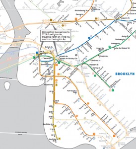
Now this is genius… MTA has released an up to-the-minute map that shows which subway lines will be operating beginning Thursday, November 1. No lines are making stops below 42nd Street, while, as you’ll also see, unfortunately, there is no service yet connecting Brooklyn Heights with Manhattan. Info about transit options connecting buses from Jay Street to NYC are in the post below here. Hold onto this link: The map will be updated daily as more subway lines are deemed safe and available for public access.
See full map below, along with a line-by-line subway & bus update from Montague Street BID. (Just added a nifty widget from the MTA, after the jump.)
Brooklyn subway service will be as follows:
2 — No service in Brooklyn
3 — No service in Brooklyn
4 — Borough Hall-New Lots Av (Local)
5 — Atlantic Av/Barclays Center-Flatbush Av (Express)
A — Jay St/MetroTech-Lefferts Blvd (Local)
B — No Service
C — No Service (See A service above)
D — Atlantic Av/Barclays Center-Bay Pkwy (Express Pacific – 36 St)
F — Jay St/MetroTech-Av X (Local)
G — No Service
L — Broadway Junction-Rockaway Pkwy (Local)
M — Myrtle Av/Broadway-Metropolitan Av (Shuttle)
Q — No Service
R — Jay St/MetroTech-95 St (Local)
S Franklin Avenue Shuttle — No Service
S Rockaway Park Shuttle — No Service
Shuttle buses:
All buses run north on 3rd Av and south on Lexington Ave.
Atlantic Ave/Barclays Center to 57 St/Lexington Ave via Manhattan Bridge
Jay St/MetroTech to 57 St/Lexington Ave via Manhattan Bridge
Hewes St to 57 St/Lexington Ave via Williamsburg Bridge

Try this handy widget from the MTA. – Homer


Source: Brooklyn Heights Blog
http://brooklynheightsblog.com/archives/50874